So 4 days had gone by and our Thursday AM hike had finally rolled around. The day was sunny and we were ready. My oldest son chose to join us for this hike.
St. Sauveur sits right next door to Acadia so getting to the hiking spot was familiar ground to us. We park in the same parking area right along Route 102. As we cross the road we choose the St Sauveur Trail that will lead to the summit of 679'. It starts with great little granite steps that welcomes all hikers to the trail along with a trail head marker.
We begin the ascent through similar forest and granite ledges as on Acadia Mountain. However, the ascent is not as steep. It's a gradual climb thru interesting surroundings and the air is cool and shady. After the first 1/2 mile we come to the first trail marker. This has the Ledge Trail to the right that has been closed for a period of time now. We continue on another 3/10 of a mile to the next marker which states it leads to the "Parking Area"... we grin and now we know how hikers get confused at this point.
As natives of Mount Desert Island we use Route 102 daily to leave Southwest Harbor. In the summer you will see hikers walking along the road behind the guard rails and not on a specific hiking path and you know they have taken a wrong turn and ended up a ways from their car and have had to "hoof it" on the roadside back to where their car is parked. You can take a turn at this Trail marker and end up in a parking area, it just won't be the "Acadia Mtn Parking area" where you started. It will lead you to the "St Sauveur Mtn Parking area" which is about a 1/2 mile from the Acadia Mtn Parking. So pay attention to which parking area you parked in. We have a good laugh at the visiting hikers expense and remembering all the times we have seen a hiker(s) that have made that mistake.
We not only paused to to discuss the parking area but to catch our breaths as that section had proven to be somewhat steeper. We both notice my son barely out of breath and we both comment that he could at least huff and puff a little to make us feel better. Seeing as he is half our age and very tall with much longer legs than us we thought we were doing pretty well.
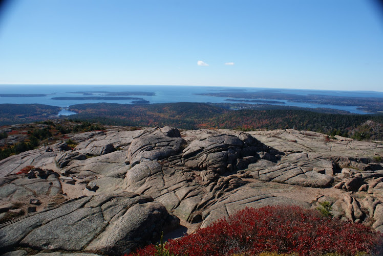
Another approx 2/10 mile brings us to the summit and we remind Renee that there is no real view at the summit marker but just through the trees we will get the reward we long for on every hike. Jesse & I had hiked St Sauveur earlier in the spring and had felt the same way at the marker. We proceed on the trail and take a left to join up with the Valley Peak Trail and the views come fast & furious here. Somes Sound lays at your feet at the base of the mountain. Acadia is to your left looking north. Valley Peak & Flying Mountains to your right looking south and south east.

The descent is steeper than the ascent had been. Be careful here if it has been wet at all as there is a lot of slopes that can be slippery. After about 8/10 of a mile you will connect to the Man O' War Brook Rd. Take a left for the trek back to the Acadia Mountain Parking Area which is also shared with those hiking the St Sauveur Mtn such as us today.
Another Thursday AM hike is in the books and we have big plans for the coming Sunday hike.
No comments:
Post a Comment