Feeling ambitious we decide to do Sargent Mountain with an elevation of 1373' and why not? Being the second highest on the island we want to cross this one off the list! We also plan to do Gilmore Peak and again we say, why not? "Two birds with one stone" sounds good to us!
We park at the Parkman Mtn parking area and start out of the parking area towards the Carriage Trail. The book tells us "follow the Carriage Road out of the parking area and turn right, then left after a short distance." So we did just that and ended up going the wrong way. So we feel it should read "follow the Carriage Road out of the parking area, turn right, then after a short distance turn right again at Carriage sign post #13". We had taken a left at this sign post and was headed up the Carriage Road towards the Parkman Mtn Trail. Having hiked this way before I knew there was a trail to cut back down to the Carriage Road below where we needed to be to get on our Hadlock Brook Trail to go up Sargent Mtn. Once again we realize the beauty of bringing the map with us. "Don't leave home without a map" is my motto when hiking.
We could have easily kept going the way we were going but we would have ended up hiking three mountains that day (instead of the two that we did hike!) and besides it's not the trail we had picked to take. We like to stick to our planned route if possible. Set a goal, attack it and achieve it. That's how we roll or hike as the case may be.
We start up the Hadlock Brook Trail and realize we love this trail. It literally follows a brook! Who knew? You wind back & forth, along side of and sometimes in the brook. How fun is that? It had rained several days prior to the hike so water was plentiful. After a little over a 1/2 mile we come to a small wooden bridge that crosses the brook and we take a few photo ops as just up the brook there is a stone bridge carrying a carriage road over the brook that will be in the background of the pictures. Great photo spot so we click away as we are in awe of the brook, the little bridge and the stone bridge while all the while not realizing there was a big waterfall just behind the stone bridge.

We continue on the Hadlock Brook Trail up to the Sargent Mountain South Ridge Trail. And to get to that trail we huffed and puffed as it goes up forever! We thought this must be the longest trail on the island at this point. However, Sargent Mtn is the most removed of all the mountains on the island. There are no easy routes to get to it or roads nearby it so you have to work a little extra to get to it's summit.
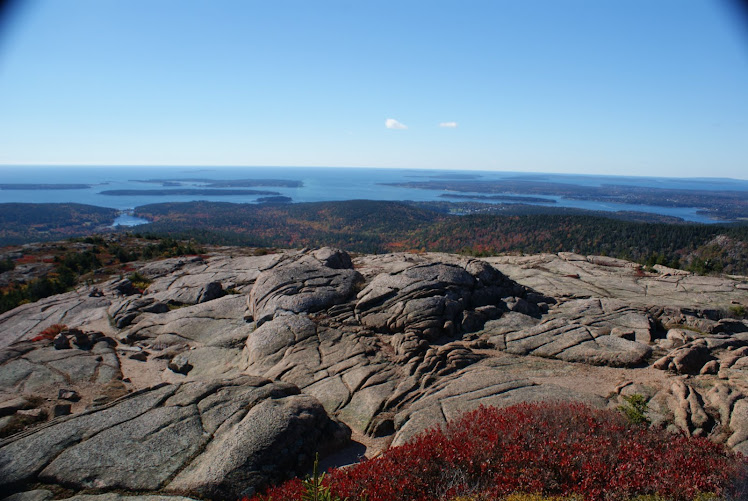
We make it to what believe to be the top. Soaked with sweat after a rigorous ascent to this point we are elated that we are close to the top or at the top. Upon further inspection of the trail sign post we learn we have another 1/2 mile to go! But the views all around are fabulous so we stop for a look around. This is as good as being at the summit as you can see in all directions. We check our map and identify several nearby mountains and other landmarks. After taking a drink of water we trudge on determined to get to the summit. As no hike is complete without visiting the summit!

A huge rock cairn sits at the summit of Sargent. It looks as though every hiker who has ever arrived here just tossed a rock on the pile. Maybe they really did. We do our usual "photo at the summit" pic to prove that we were here. We looked around and snapped some shots of all the views and listen to the quiet.
We get back to hiking as the clouds are rolling in and we have another summit yet to conquer. We backtrack for a bit then pick up the Maple Spring Trail. We are soon visited by what we believe to be a young turkey vulture. A huge brown bird with lighter brown on the outer wings who seemed as curious about us as we did about it. The bird would land near us then fly off as we approached it for pictures. It would come back to get another look. The bird did this several times. We hoped it didn't mind us being in it's territory as we were clearly the intruders. It was soon bored with us and took flight down the mountainside.


We get our summit picture, backtrack on the trail we had just come on and pick up a trail to continue the descent down the mountain. We actually pick up the Maple Spring Trail here that will take us all the way back to the carriage road below that will lead us to the parking area where we started. Again, aptly named the trail follows a brook, crosses the brook, and at times is the brook. We discuss how this would be much wetter and much more full of water during spring run off after a snowy winter. We are thankful we are here now and not in the spring.
The trail amazes us all the way down how it quite literally is the brook for part of the way. We go under a stone bridge that carries the Around the Mountain Carriage Road above us. At the second stone bridge we go up and pick up the Carriage Road as our feet are getting sore and hot from the long trek and the Carriage Road is a welcome feeling to our feet after scaling over rocks & roots for a period of time. The smooth gravel road is a dream come true for our feet. We make our way back to the parking area via the Carriage Road and are pleased as punch with our accomplishments for the day. Not only did we hike two mountains, see the largest waterfall on MDI, met a young turkey vulture and hopped along the rocks on several brook trails we had shared our love of hiking and our friendship with one another again.
No comments:
Post a Comment