Acadia

Acadia
View from Penobscot Mountain

Monday, November 8, 2010

Valley Peak & Flying Mountain Hike

September 22, 2010 - Valley Peak (Elev. 530') & Flying Mountain (Elev. 284') - Hike #5 -
Today's hike takes place on a Wednesday morning instead of the usual Thursday morning due to schedules & weather. But we make it hiking that is all that matters! We head down the Fernald Point Road in SW Harbor and we park in the parking area at the base of Flying Mountain.

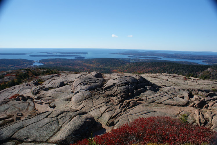
Flying is the smallest mountain on MDI so we knew the hike wouldn't take long so we had to extend the route to fill our morning. We couldn't go back to work too early! We started at the gate in the parking area at the end of the Valley Cove carriage road.  We head down the carriage road for about a tenth of a mile and take the Valley Peak Trail and leads to the west & north up to Valley Peak. The trail is more rugged than we anticipated. A very shady hike that goes up and up. We arrive at the summit in about 4/10 of a mile. The summit has great views if you step out towards the edge of the mountain a little as the summit marker is a bit back in the woods. The mouth of Somes Sound as well as Southwest Harbor lie below us. The sun is shining and we can check off mountain #1 for the day.

We proceed on the Valley Cove Trail that will eventually take us across and down St Sauveur Mountain. Having hiked St Sauveur a few weeks ago the scenery is familiar but we never tire of it as it's such a beautiful spot we don't mind that we get to see it again. Today a sailboat is moored in Valley Cove below us. We discuss how the people probably dropped anchor in the night and have slept in and will be up soon to have breakfast in a cozy little cove off the coast of Maine. We smile and just imagine for a bit. Then the hike continues. We check off mountain #2 for the day.

Down to the Man 'O War Brook Road we go to pick up the Flying Mountain Trail that will follow along the edge Valley Cove back to Flying Mountain. The Flying Mountain Trail starts out as mostly wooded then as you get closer to the cove it opens up for small views along the shoreline where the trees are thinner. We catch a nice breeze off the water that cools us off from all of our hard work. As quick as the shoreline has appeared it disappears. We are a little disappointed as we thought we would see the small sailboat up close. But not to worry as the trail winds around the west side of the cove we do get to see it again and up close!

The trail leads up and down and over, up and down and over rocks then to an open ledge area that follows closely to a very steep ledge cliff. Unlike any trail we have seen so far we take some time here to check out the view of the cove with the small sailboat and the sheer size of the ledge cliff we are passing. By the way, no activity on the boat and no breakfast to be seen so far. Renee is worried that they may not be okay. I think they are on vacation on a sailboat in Maine and have no real concept of time!

We continue on past the ledge cliff and back into a wooded area of the trail that is now skirting the base of St Sauveur Mountain. We come across an interesting flowering plant. We still have to look it up to see what it was. I have lived here all my life and have never seen a plant like this before. Long reddish, dark pink stem with multiple little stems that had a white ball a the end each little stem. Maybe the flower petals had fallen off already or maybe it really looks this way in bloom. We don't know. A mystery yet to be solved.


We continue along the trail and come to a boulder field that sits beside the cove. We are impressed with all the rocks but not the fact that the trail goes through them. We meet a young couple. She doesn't look too excited about the boulder field either. The rocks have to be scrambled up and over to make our way to the other side. I look around and up and notice the cliffs that make up the east side of St Sauveur so I mention it to Renee and stop for some pictures. We had just been over them and under them so looking back at them was quite eye opening to say the least. Well, at that very moment Renee was not doing so well. Did I mention my hiking buddy is afraid of heights? Well, she is but never lets it stop her. Until today. She has no control of when the feeling hits, it just does.


We pass the Valley Cove carriage road and proceed along the cove to make our way up Flying Mountain.
We take a quick look back across the cove to the boulder field that we had just conquered. Renee is proud of her accomplishment, as she should be. That was tough to do and she had done it. We meet many people as we proceed up to the summit. Being the smallest mountain means you are also a busy mountain as it's a quick & fun hike for many who normally don't hike a lot. The trail has a gradual incline to it through wooded areas and a few open ledges.

We come to the summit after just 284' which seems so sudden compared to all the others we have done. There is an open ledge that overlooks Somes Sound and the tip of Fernald Point. We know a lady that has a home on the point so we look her property over from this view. We take our usual summit photo to once again get the proof we need that we were here! The summit is a busy place with people coming and going all across it. The trail loops around the top of Flying Mountain before descending back down to the parking area. On our descent we meet even more hikers along the trail making this hike one of the busiest yet. Mountain #3 done for the day. Time to get back to work.

When we get to the parking area we see a couple parked beside my Jeep that we had met on the trail on north side of Flying Mountain. The man comments how that was a quick hike for us. Thinking we had only done Flying Mountain and returned to the Jeep. We were quick to inform him that we had done Valley Peak, gone across St Sauveur Mountain, around Valley Cove then done Flying Mountain. He retracted his statement as we then told him we had to get back to work. The couple were quite jealous that we have Acadia in our backyard. We were quite proud & happy that we do.

Sunday, October 24, 2010

Sargent Mountain & Gilmore Peak Mountain Hike

September 19, 2010 - Sargent Mountain (Elev 1373') & Gilmore Peak Mountain - (Elev. 1036') - Hike #4
Feeling ambitious we decide to do Sargent Mountain with an elevation of 1373' and why not? Being the second highest on the island we want to cross this one off the list! We also plan to do Gilmore Peak and again we say, why not? "Two birds with one stone" sounds good to us!

We park at the Parkman Mtn parking area and start out of the parking area towards the Carriage Trail. The book tells us "follow the Carriage Road out of the parking area and turn right, then left after a short distance." So we did just that and ended up going the wrong way. So we feel it should read "follow the Carriage Road out of the parking area, turn right, then after a short distance turn right again at Carriage sign post #13". We had taken a left at this sign post and was headed up the Carriage Road towards the Parkman Mtn Trail. Having hiked this way before I knew there was a trail to cut back down to the Carriage Road below where we needed to be to get on our Hadlock Brook Trail to go up Sargent Mtn. Once again we realize the beauty of bringing the map with us. "Don't leave home without a map" is my motto when hiking.

We could have easily kept going the way we were going but we would have ended up hiking three mountains that day (instead of the two that we did hike!) and besides it's not the trail we had picked to take. We like to stick to our planned route if possible. Set a goal, attack it and achieve it. That's how we roll or hike as the case may be.

We start up the Hadlock Brook Trail and realize we love this trail. It literally follows a brook! Who knew? You wind back & forth, along side of and sometimes in the brook. How fun is that? It had rained several days prior to the hike so water was plentiful.  After a little over a 1/2 mile we come to a small wooden bridge that crosses the brook and we take a few photo ops as just up the brook there is a stone bridge carrying a carriage road over the brook that will be in the background of the pictures. Great photo spot so we click away as we are in awe of the brook, the little bridge and the stone bridge while all the while not realizing there was a big waterfall just behind the stone bridge.

Remembering now that the book had said we would see the largest waterfall on MDI on this trail. We were thrilled to find it! Just after after passing under the bridge the stone steps led us to the base of the waterfall. And what a treat! I felt like I was in Maui or somewhere tropical and not in Maine. Lived here all my life and never knew a waterfall, let alone one that size, was on our island! Renee felt the same way. Again, we were thrilled at our find. We would have loved to stay longer but we had hiking to get done!
We continue on the Hadlock Brook Trail up to the Sargent Mountain South Ridge Trail. And to get to that trail we huffed and puffed as it goes up forever! We thought this must be the longest trail on the island at this point. However, Sargent Mtn is the most removed of all the mountains on the island. There are no easy routes to get to it or roads nearby it so you have to work a little extra to get to it's summit.
We make it to what believe to be the top. Soaked with sweat after a rigorous ascent to this point we are elated that we are close to the top or at the top. Upon further inspection of the trail sign post we learn we have another 1/2 mile to go! But the views all around are fabulous so we stop for a look around. This is as good as being at the summit as you can see in all directions. We check our map and identify several nearby mountains and other landmarks. After taking a drink of water we trudge on determined to get to the summit. As no hike is complete without visiting the summit!

The top of Sargent seems so desolate compared to all the other mountains on MDI. It's open & barren and seems as though it's a loner among it's neighbors. We find beauty in it as well as the peace & quiet here is staggering. Just you, the sky, a slight breeze and the mountain.

A huge rock cairn sits at the summit of Sargent. It looks as though every hiker who has ever arrived here just tossed a rock on the pile. Maybe they really did. We do our usual "photo at the summit" pic to prove that we were here. We looked around and snapped some shots of all the views and listen to the quiet.

We get back to hiking as the clouds are rolling in and we have another summit yet to conquer. We backtrack for a bit then pick up the Maple Spring Trail. We are soon visited by what we believe to be a young turkey vulture. A huge brown bird with lighter brown on the outer wings who seemed as curious about us as we did about it. The bird would land near us then fly off as we approached it for pictures. It would come back to get another look. The bird did this several times. We hoped it didn't mind us being in it's territory as we were clearly the intruders. It was soon bored with us and took flight down the mountainside.

 We continue along the trail after our visit from the young turkey vulture. We drop a couple hundred feet in elevation before arriving at Gilmore Peak. The summit sits at 1036' and the summit sign post shows it's age. It is very weather worn and does not look like all the others. The views are similar to Sargent only to the South & West and partial North views. None really to the East as that's where Sargent sits and having dropped below the top of Sargent views to the east are just tree tops.

We get our summit picture, backtrack on the trail we had just come on and pick up a trail to continue the descent down the mountain. We actually pick up the Maple Spring Trail here that will take us all the way back to the carriage road below that will lead us to the parking area where we started. Again, aptly named the trail follows a brook, crosses the brook, and at times is the brook. We discuss how this would be much wetter and much more full of water during spring run off after a snowy winter. We are thankful we are here now and not in the spring.

The trail amazes us all the way down how it quite literally is the brook for part of the way. We go under a stone bridge that carries the Around the Mountain Carriage Road above us. At the second stone bridge we go up and pick up the Carriage Road as our feet are getting sore and hot from the long trek and the Carriage Road is a welcome feeling to our feet after scaling over rocks & roots for a period of time. The smooth gravel road is a dream come true for our feet. We make our way back to the parking area via the Carriage Road and are pleased as punch with our accomplishments for the day. Not only did we hike two mountains, see the largest waterfall on MDI, met a young turkey vulture and hopped along the rocks on several brook trails we had shared our love of hiking and our friendship with one another again.

Monday, October 18, 2010

St. Sauveur Mountain

Thursday September 16, 2010 - St. Sauveur Mountain - Elev. 679' - Hike #3
So 4 days had gone by and our Thursday AM hike had finally rolled around. The day was sunny and we were ready. My oldest son chose to join us for this hike.

St. Sauveur sits right next door to Acadia so getting to the hiking spot was familiar ground to us. We park in the same parking area right along Route 102. As we cross the road we choose the St Sauveur Trail that will lead to the summit of 679'. It starts with great little granite steps that welcomes all hikers to the trail along with a trail head marker.

We begin the ascent through similar forest and granite ledges as on Acadia Mountain. However, the ascent is not as steep. It's a gradual climb thru interesting surroundings and the air is cool and shady. After the first 1/2 mile we come to the first trail marker. This has the Ledge Trail to the right that has been closed for a period of time now. We continue on another 3/10 of a mile to the next marker which states it leads to the "Parking Area"... we grin and now we  know how hikers get confused at this point.

As natives of Mount Desert Island we use Route 102 daily to leave Southwest Harbor. In the summer you will see hikers walking along the road behind the guard rails and not on a specific hiking path and you know they have taken a wrong turn and ended up a ways from their car and have had to "hoof it" on the roadside back to where their car is parked. You can take a turn at this Trail marker and end up in a parking area, it just won't be the "Acadia Mtn Parking area" where you started. It will lead you to the "St Sauveur Mtn Parking area" which is about a 1/2 mile from the Acadia Mtn Parking. So pay attention to which parking area you parked in. We have a good laugh at the visiting hikers expense and remembering all the times we have seen a hiker(s) that have made that mistake.

We not only paused to to discuss the parking area but to catch our breaths as that section had proven to be somewhat steeper. We both notice my son barely out of breath and we both comment that he could at least huff and puff a little to make us feel better. Seeing as he is half our age and very tall with much longer legs than us we thought we were doing pretty well.

Another approx 2/10 mile brings us to the summit and we remind Renee that there is no real view at the summit marker but just through the trees we will get the reward we long for on every hike. Jesse & I had hiked St Sauveur earlier in the spring and had felt the same way at the marker. We proceed on the trail and take a left to join up with the Valley Peak Trail and the views come fast & furious here. Somes Sound lays at your feet at the base of the mountain. Acadia is to your left looking north. Valley Peak & Flying Mountains to your right looking south and south east.
Cars can be seen driving along Sargent Drive on the other side of the Sound and many summer homes dot the shores of Northeast Harbor. We take time to watch a few lobster boats working traps in the Sound. We feel the pull to leave as work calls for all three of us this morning. We make our way along Valley Peak Trail heading north now to Man O' War Brook to make a loop as we like to do on our hikes so the scenery is different all the time.

The descent is steeper than the ascent had been. Be careful here if it has been wet at all as there is a lot of slopes that can be slippery. After about 8/10 of a mile you will connect to the Man O' War Brook Rd. Take a left for the trek back to the Acadia Mountain Parking Area which is also shared with those hiking the St Sauveur Mtn such as us today.

Another Thursday AM hike is in the books and we have big plans for the coming Sunday hike.

Saturday, October 16, 2010

Acadia Mountain

September 12, 2010 - Acadia Mountain Elev. 681' - Hike #2 -
Well just 3 days after the first hike we head out for the second one on a Sunday morning. That is the plan, that Thursday & Sunday mornings to hike in Acadia will be the schedule unless life gets in the way then we improvise and reschedule. It was predicted to be sunny but a few clouds were deciding to hang tough. But that didn't dampen our spirits. The temp was cooler this mornin' but again we are Mainers you can scare us off that easy.
We parked in the Acadia Mountain parking area right along the roadside on Route 102. We cross the road to start the hike by going in by the metal gate that is the entrance to the Man O' War Brook Road. We follow that for a bit then take a left at the start of the Acadia Mountain Trail.
We have both hiked Acadia before but not together. So the ascent begins and we gain elevation quickly. There is many different types of trees to look at heading up Acadia. Most of them are pine trees with several varieties adding interest to the hike. They each seem to have their own grove as you continue to climb. Many places are steep and require quite the leg stretches and use of hands to reach your destination. We find we are not as easily winded today as we are getting conditioned to the cardio but we do notice that talking and laughing uses a fair amount of oxygen as well!
We come upon many open ledge areas that gives you views to the west and you can see parts of Echo Lake below. You can see neighboring Beech Mountain, where we had just been 3 days ago, as well as Mansell Mtn to the west. The skies are not clear but it's not completely overcast either. But we don't seem to mind as long as it's not raining and we are hiking. Many of the open ledge areas have grooves in them and it seems over time water has carved it's name in the stone.

We continue up the mountain and continue our chit chat back & forth. Sometimes it seems to be the fuel that helps propel us up the mountain. We stop for a brief moment at another overlook area to the west and discuss if the mountain range in the way distant to the west could possibly be the White Mountains. We doubt it as the skies are not super clear today and could we really see that far into New Hampshire? We debate it and discuss it and realize we must look it up upon our return to civilization. Of course Renee suggests she should have brought her partners hand held GPS that he suggested she bring and we quickly distinguish that thought! We laugh some more and off we go to the summit.

As you come upon the summit of Acadia it is like the world opens up in front of you. Somes Sound and the Atlantic Ocean seems to say "Hello & Welcome, we've been waiting for you". You stand in awe and just say Wow. All the outer islands off Southwest Harbor lay quietly to the south. We wonder why it took us so long to hike Acadia again.
The water wasn't a brilliant blue as usual today but it gave off a serene and peaceful vibe as we stood and stared at our surroundings. We know then that we will hike Acadia again as it is one of the best on MDI.
And since the sun was not as brilliant today we know we will be back again to see it on a crisp sunny fall or spring day.

We take a "timed" photo of us both at the summit and realize we have to do this every time to "prove we were here". We don't know who we are proving it to but that is beside the point. I learned that 10 seconds is longer than you think to get in the shot.

After soaking in the summit of Acadia we make our way along the trail to begin  the descent and we realize after a brief few minutes that there really is not a bad view coming down the Acadia Mountain Trail going in the direction we chose. We did not back track the same way we had come we had continued on to make the hike a loop. We were headed for the base of the mountain to the Man O' War Brook Road. We can see the Sound and Valley Cove as well St. Sauveur & Flying Mountains ahead of us to the south and this view continues the whole way down the trail.

We say it over and over..."there is no bad view coming down this way" or "we get a view all the way down, can you believe it?". We both can't remember that from the previous time we had hiked Acadia. For me it had been awhile and I had had my husband & two sons with me. The boys were younger so I had to help watch their footings as well as my own that day so I believe I missed the views or had really forgotten how beautiful this mountain hike really is. You keep seeing the view as you zig zag down the trail until you get below the tree tops and by then you are almost to the Man O' War Brook Rd. We take a right at the trail marker at the bottom and head west out on the Man O' War Brook Rd.

Our feet welcomes the flat and smoother terrain. The road has had been washed out in many areas again due to the unusual heavy rains we have had the past spring and in the fall of 2009. Park crews have yet to rebuild as I am sure the priority isn't high in this particular spot as it is still very safe & passable. They have many trails to maintain and will get to this road when they can.
On the walk back to the truck we plan the next hike just the addict plans the next fix. We will head out in 4 days to the next summit to be conquered.

Thursday, October 14, 2010

Beech Mountain

I had a good friend ask me this fall if I had time to hike once in awhile. Being the person I am and having a love of hiking but never wanting to go alone I jumped at the chance. This blog is to share what we consider to be our own experiences and we want to share with others what the hiking books and maps don't always tell you. We are recounting our hiking trips that we have been doing for well over a month now as the idea came to us on of all places, a hike, today (Oct 14, 2010) I start with our first hike together.

September 9, 2010 - Beech Mountain Elev 839' via the trail from my house, to the South Ridge Trail, to the summit of Beech Mountain and down the West Ridge Trail along Long Pond and back home.
Our first hike together as hiking partners began at my house on a warm sunny day. The beauty of living on Mount Desert Island is you have a hiker's paradise in your backyard! We took the connector trails from my house and began the ascent up the South Ridge Trail. This trail has had extensive work done to it this summer and fall (2010). Many blow down trees and serious water run off from heavy rain storms had damaged the trail. The Park Service has spent many hours rebuilding and constructing the route the zig zags up the bump that connects to the fire tower mountain. Several spots along the way you can view surrounding areas to the south such as Southwest Harbor and to the west such as Seal Cove, etc. Take time to catch your breath as elevation gain is quick here and take in the sights of the off shore coastline that is now visible from time to time.

We approach the fire tower and views explode behind us. It's been years since we have hiked Beech Mtn and now we wonder why we waited so long.
The views are mostly to the east, south and some towards the west. None really to the north.
We do not go up in the fire tower as it's closed most of the time and only open on special days the Park Service holds tours.

After catching our breath as we are a tad red faced and winded from a summer of no hiking. But now rejuvenated with the hiking fever! We are supposed to be at work as it's a Thursday morning so we opt to take the West Ridge trail for our descent. And why not? We will end the hike along the banks of Long Pond in Southwest Harbor. Not bad for a morning at work!
The West Ridge Trail descends quickly with mostly open ledges to start but several spots are rocky and rooty on the way down. More rocks than roots. When you come to a parking area or dirt road area remain along the shore for a great cool walk back to the pumping station parking area. This trail has several wooden bridges along the shore that are part of the trail.
We take the road back to my house and now we are convinced we have to continue this new found addiction at least twice a week. Our next hike already being planned before we finished the Beech Mountain hike. We not only share a love of the outdoors and hiking we share a love of laughing as well.